Reach New Heights with Korea’s National Parks! Best Hiking Trails in Korea
-
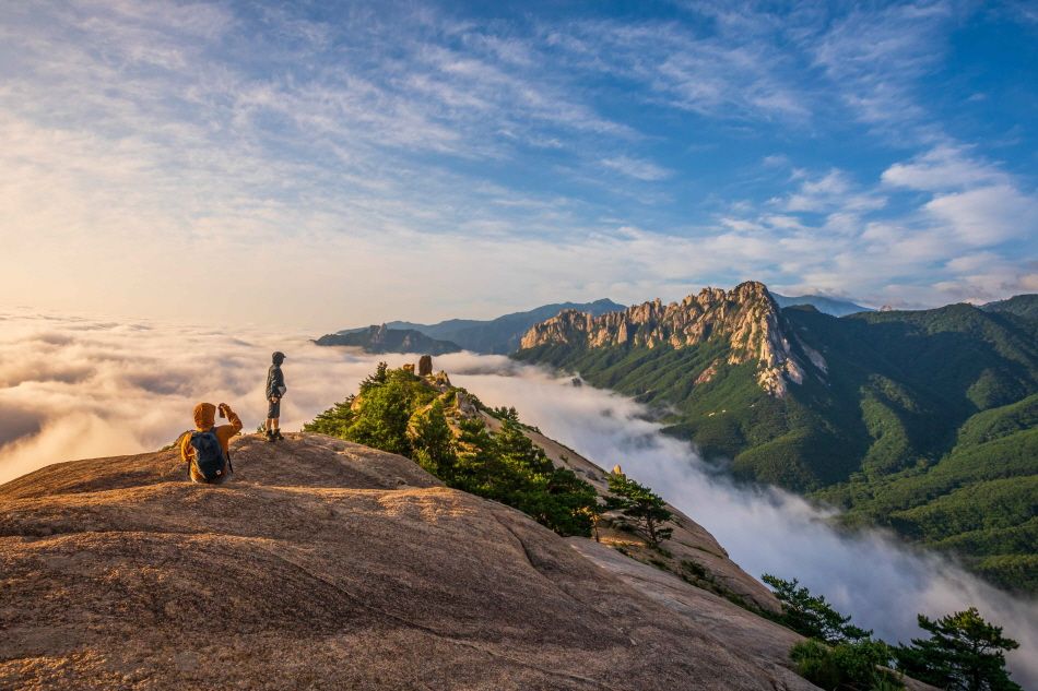 Hikers take pictures with Ulsanbawi Rock of Seoraksan Mountain in the distance
If you appreciate the gift of nature, head to one of Korea’s national parks for a hiking trip. From Seoraksan Mountain, with rough ridges and rock formations, to Hallasan Mountain, boasting its mystical scenery, and Bukhansan Mountain, with a panoramic view of Seoul, Korea’s national parks await your visit. Whether you are a beginner who appreciates easygoing walks along forest trails or a seasoned hiker who scales great cliffs and deep valleys, these hiking trails have something for everyone.
1. Bukhansan Mountain
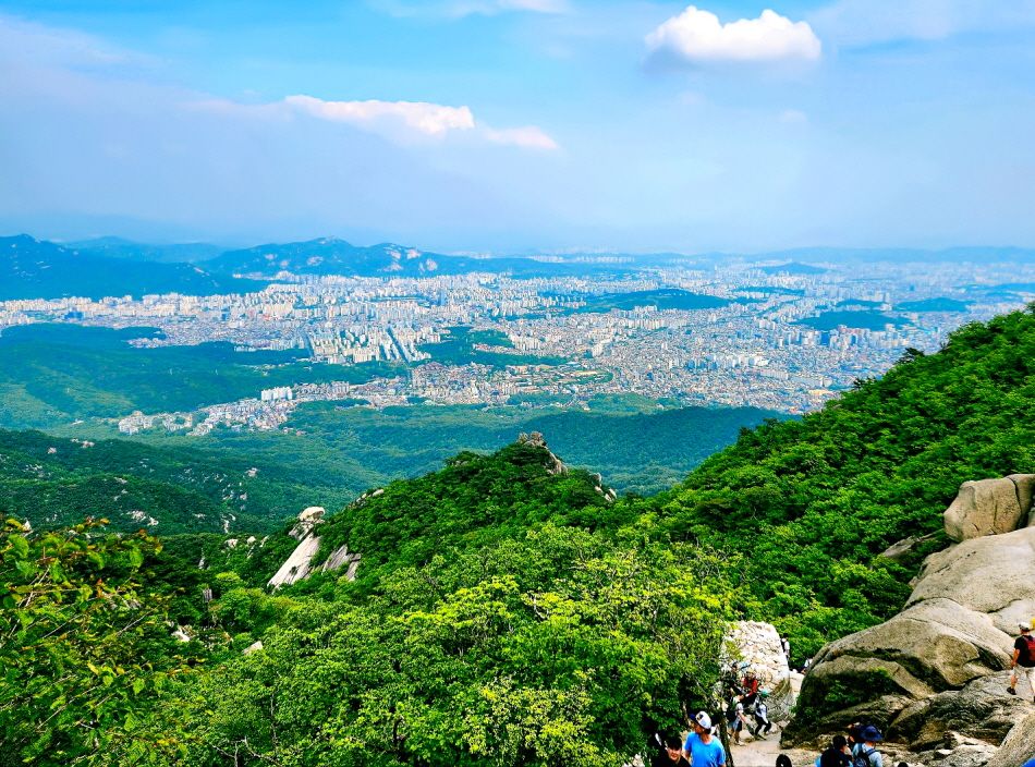 The view of Seoul from Bukhansan Mountain
Located in the northern part of Seoul, Bukhansan National Park is a great place to enjoy the vastness of nature in a big city. Bukhansan Mountain refers to a collection of peaks around Seoul and northern Gyeonggi-do. Because of its location, it is interwoven into an excellent public transportation network, allowing easy access to its hiking trail entrances.
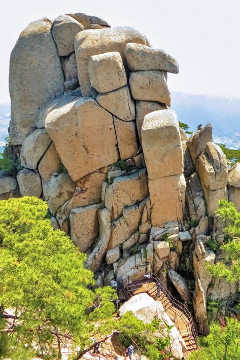
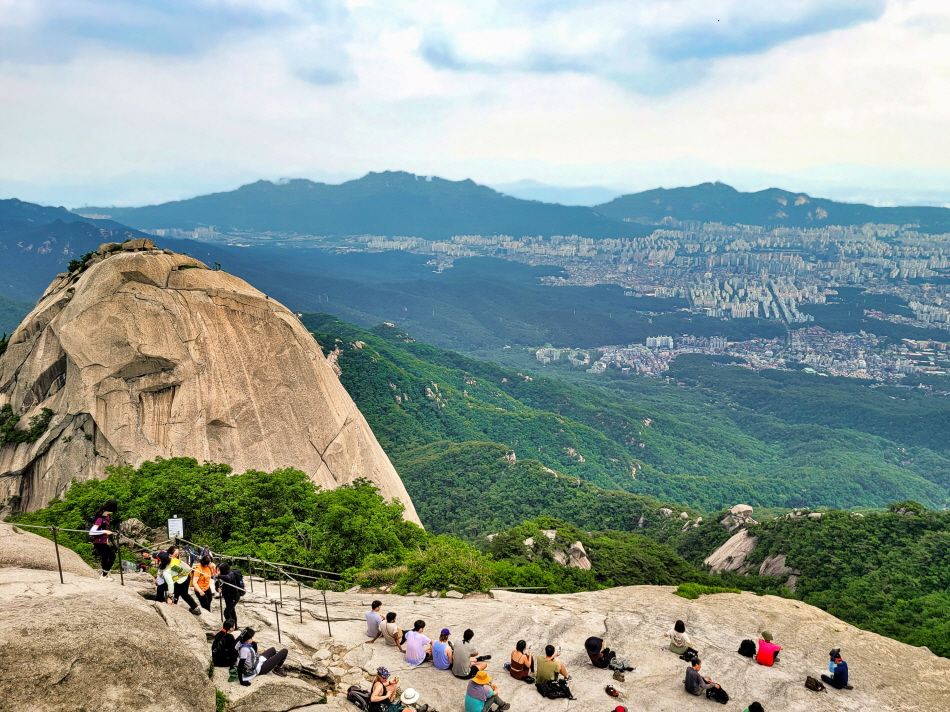 Parts of Bukhansan Mountain’s Baegundae Trail
-
 Parts of Bukhansan Mountain’s Baegundae Trail
 -
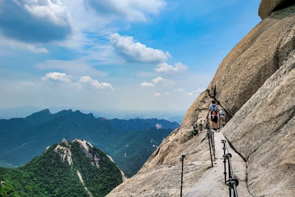
 A section of Sinseondae Trail
Bukhansan Mountain is also a place where the history and culture of Korea live and breathe: A monument erected on Bibong Peak, one of the rocky ridges of the mountain, by King Jinheung of Silla in the 6th century to commemorate his visit to the kingdom’s borders, was designated as a natural treasure of Korea and is now housed in the National Museum of Korea. Bukhansanseong Fortress, built on the way to Baegundae Peak, Bukhansan Mountain’s highest peak, offers a great photo spot to capture the area’s scenery.
| Recommended Trails
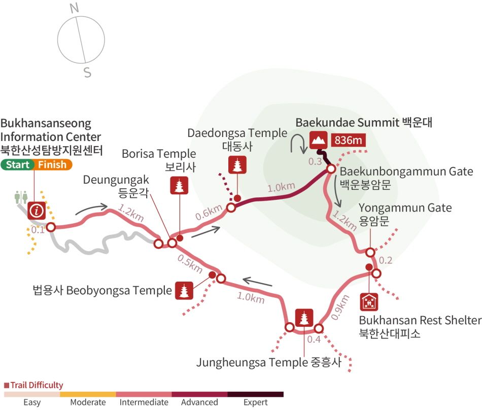
• Baegundae Trail
- Length: 9 km
- Time taken: 5 hr
- Course: Bukhansanseong Information Center → Deungungak Pavilion → Baegundae Peak → Yongammun Gate → Jungheungsa Temple → Bukhansanseong Information Center
- Starting point: Bukhansanseong Parking Lot 1, 24 Daeseomun-gil, Eunpyeong-gu, Seoul (서울특별시 은평구 대서문길 24 북한산성 제1주차장)
- How to get there: Take Bus No. 704 from Seoul Station Bus Transfer Center → Get off at Bukhansanseong Entrance Bus Stop
- Tip! Bukhansan Shelter is an unmanned rest area for hikers.
Hiking the National Parks of Korea
This trail takes you from Bukhansanseong Information Center to Deungungak Pavilion, Baegunbongammun Gate, and eventually to Baegundae Peak. It is quite steep, but there are rest areas built along the trail, so you can take the trail at your own pace. At the peak, you can take your pic of the day, enjoying an expansive view of downtown Seoul and Bukhansan Mountain. Note that some sections of the trail (Daedongsa Temple – Baegunbongammun Gate – Yongammun Gate) are closed because of the risk of rockfall at the present moment, so make sure to check whether the trail is open before your visit.
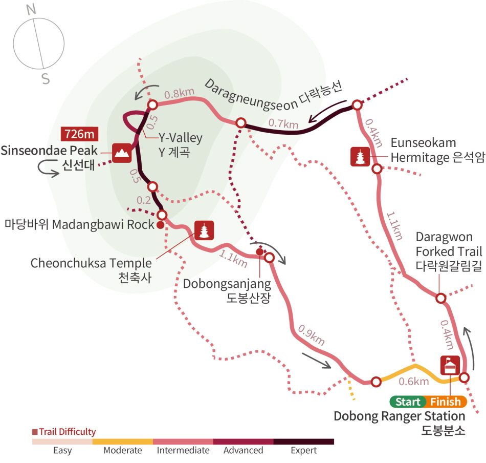
• Sinseondae Trail
- Length: 7.2 km
- Time taken: 4 hr 30 min
- Course: Dobong Ranger Station → Eunseogam Hermitage → Darangneungseon Ridge → Y Valley → Sinseondae Peak → Madangbawi Rock → Dobong Ranger Station
- Starting point: Dobongsan Public Parking Lot, 282-26 Dobong-dong, Dobong-gu, Seoul (서울특별시 도봉구 도봉동 282-26 공영도봉산주차장)
- How to get there: Take the subway to Dobongsan Station on Seoul Subway Line 1 → 20 min hike to the entrance of the hiking trail
- Tip! For safety reasons, you must follow the directions displayed on the map at the Y Valley section.
Hiking the National Parks of Korea
This trail from Dobong Ranger Station upward to Sinseondae Peak via Eunseogam Hermitage and Darangneungseon Ridge is a trail where you encounter the many faces of Dobongsan Mountain. For instance, you can see the tranquil scenery of Eunseogam Hermitage, the grandeur of Darangneungseon Ridge, and the steep rocks of the Y Valley in one hiking trip. Take a breather at Madangbawi Rock (“Madang,” meaning a wide land) before descending past Cheonchuksa Temple toward Dobong Ranger Station. The trail down is much gentler than the way up, so you can easily complete your visit.
| Nearby Attraction
• Seoul Hiking Tourism Center - Bukhansan Branch
 Equipment rental space within the Seoul Hiking Tourism Center
Seoul Hiking Tourism Center offers tourist information services tailored to international hikers. It offers information on Seoul’s major hiking trails in Korean, English, Chinese, and Japanese and offers equipment such as hiking shoes and clothing for rental. The center also offers experience programs for international visitors, as well as lockers (both free and paid) for luggage storage and lounges for resting.
2. Seoraksan Mountain
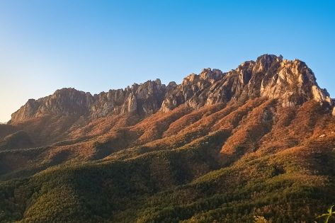
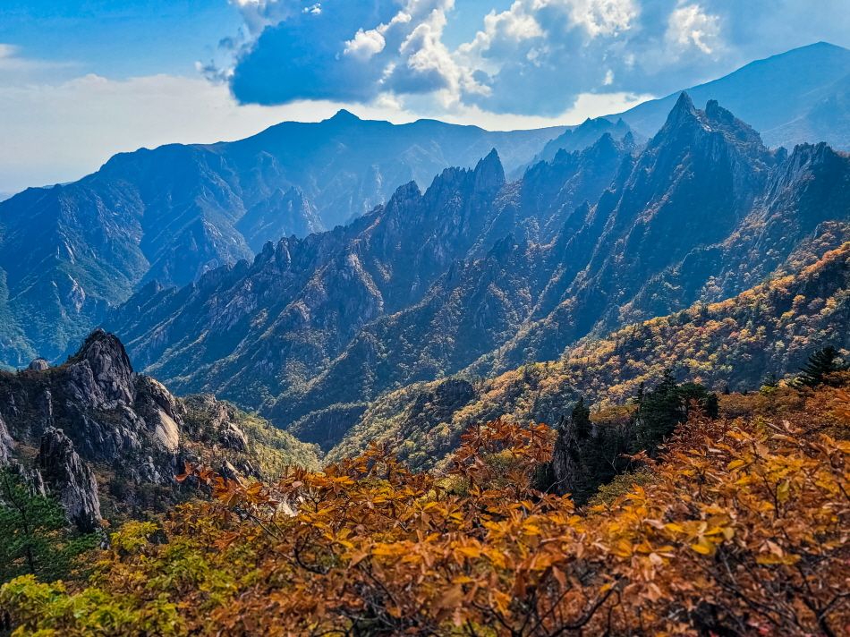 Seoraksan Mountain’s Gongnyongneungseon Ridge
Seoraksan National Park, the first place in Korea to be designated as a UNESCO Biosphere Reserve in 1982, is the second largest national park in Korea. It is famous among tourists, nature lovers, and hikers for its beautiful scenic features, such as the Gongnyongneungseon Ridge and Cheonbuldonggyegok Valley.
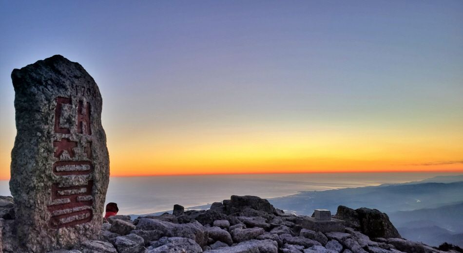 Daecheongbong Peak at Seoraksan Mountain
-
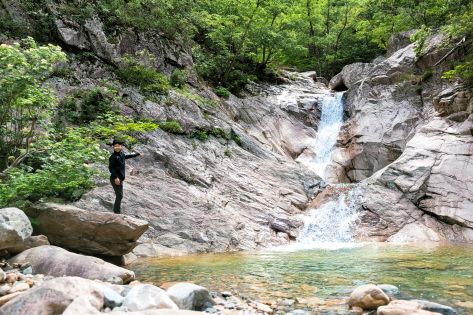 Cheondangpokpo Falls
 -
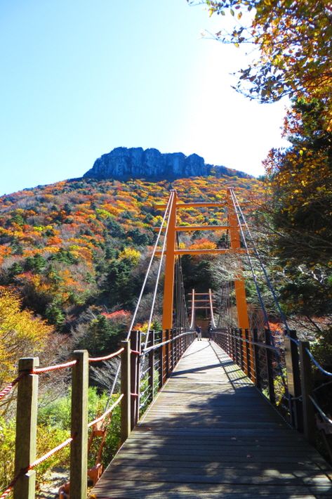
 Ulsanbawi Rock
Seoraksan Mountain’s roughness is only matched by its beauty. The way to the summit is not easy but certainly fulfilling. Many visitors stay overnight at the shelter at the midway point before climbing to the peak. If you want an easier hike, we recommend the trail along the stream in the valley leading to Biseondae Peak. If you are with seniors or children, you can take the cable car to Gwongeumseong Fortress, a mountain fortress built during the Goryeo period, to enjoy the panoramic view of the area and take a picture with the majestic Ulsanbawi Rock as a backdrop.
| Recommended Trails
• Daecheongbong Trail
- Length: 16 km
- Time taken: 10 hr
- Course: Sogongwon Park → Biseondae Peak → Huiungak Shelter → Daecheongbong Peak → Namseorak (Osaek)
- Starting point: Seoraksan Sogongwon Park, 1055 Seoraksan-ro, Sokcho-si, Gangwon-do (강원특별자치도 속초시 설악산로 1055 설악산소공원)
- How to get there: Take Bus No. 7 or 7-1 from Sokcho Intercity Bus Terminal → Get off at Seoraksan Sogongwon Park Bus Stop
- Tip! Closures for forest fire prevention
- Many sections of Seoraksan Mountain’s hiking trails are closed during the forest fire prevention period.
- - Sections closed: Upper areas - Biseondae Canyon to Daecheongbong Peak
- - Open sections: Sogongwon Park entrance to Biseondae Canyon
- - Period: March 2 – May 15 / November 15 – December 15
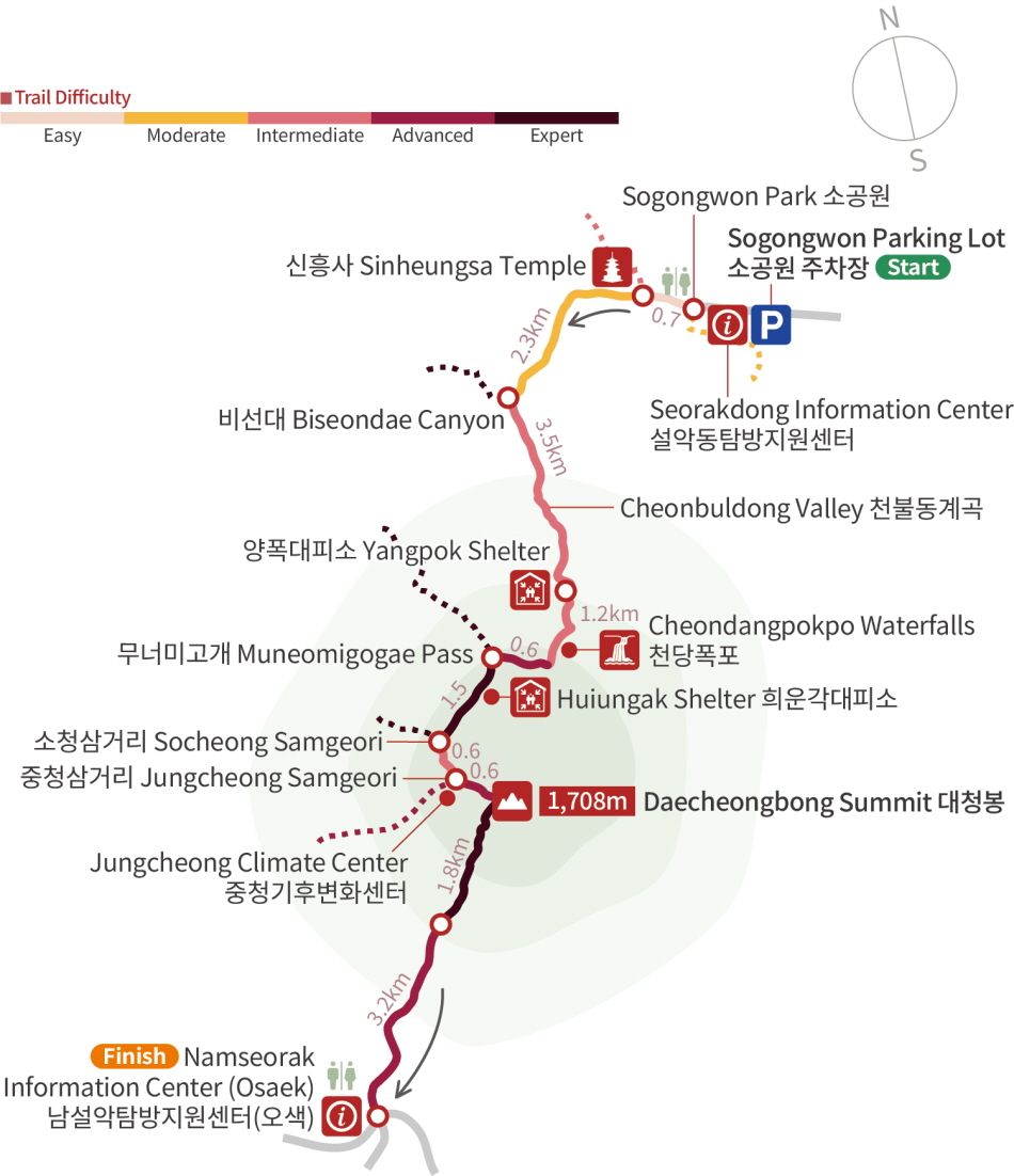
Hiking the National Parks of Korea
This hiking trail, which brings you from Sogongwon Park to Daecheongbong Peak, the mountain’s highest peak, through the wide and massive rock formation of Biseondae Peak and the beautiful Cheondangpokpo Falls, is the best way to experience the beauty of Seoraksan Mountain. It starts off with an easy walk along lush forest trails but eventually becomes an arduous climb along steep slopes from Cheondangpokpo Falls. However, the view at the summit and the majesty of the Gongnyongneungseon Ridge and Ulsanbawi Rock are more than enough to make up for that.
• Ulsanbawi Trail
- Length: 7.6 km
- Time taken: 4 hr
- Course: Sogongwon Park → Sinheungsa Temple → Heundeulbawi Rock → Ulsanbawi Rock → Sogongwon Park
- Starting point: Seoraksan Sogongwon Park, 1055 Seoraksan-ro, Sokcho-si, Gangwon-do (강원특별자치도 속초시 설악산로 1055 설악산소공원)
- How to get there: Take Bus No. 7 or 7-1 from Sokcho Intercity Bus Terminal → Get off at Seoraksan Sogongwon Park Bus Stop
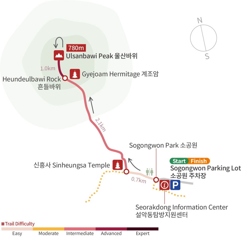
Hiking the National Parks of Korea
The forest path from Sogongwon Park to Sinheungsa Temple and Heundeulbawi Rock is gentle, so it is quite accessible to visitors of all skill levels. Heundeulbawi Rock is a photo area popular among tourists, many of whom often try to shake the rock to test the veracity of its name (“heundeul” means wobbling). The path from Heundeulbawi Rock to Ulsanbawi Rock is rather steep, but the view from the summit is worth every drop of sweat. Ulsanbawi Trail is ideal for those who want to sample the beauty of Seoraksan Mountain but don’t have the time or stamina for a longer hike.
| Nearby Attraction
 Traditional Patterns on Baekdamsa Temple’s Eaves
Baekdamsa Temple has a reputation of being one of the most beautiful temples in Korea, and for good reason. In particular, the surrounding mountains erupt in majestic red in fall, creating a scenery straight out of a landscape painting. It is a great place to enjoy meditation in peace and quiet. It also offers Templestays for international visitors, so if you want to experience life in a Buddhist temple in Korea, check out their programs.
3. Hallasan Mountain
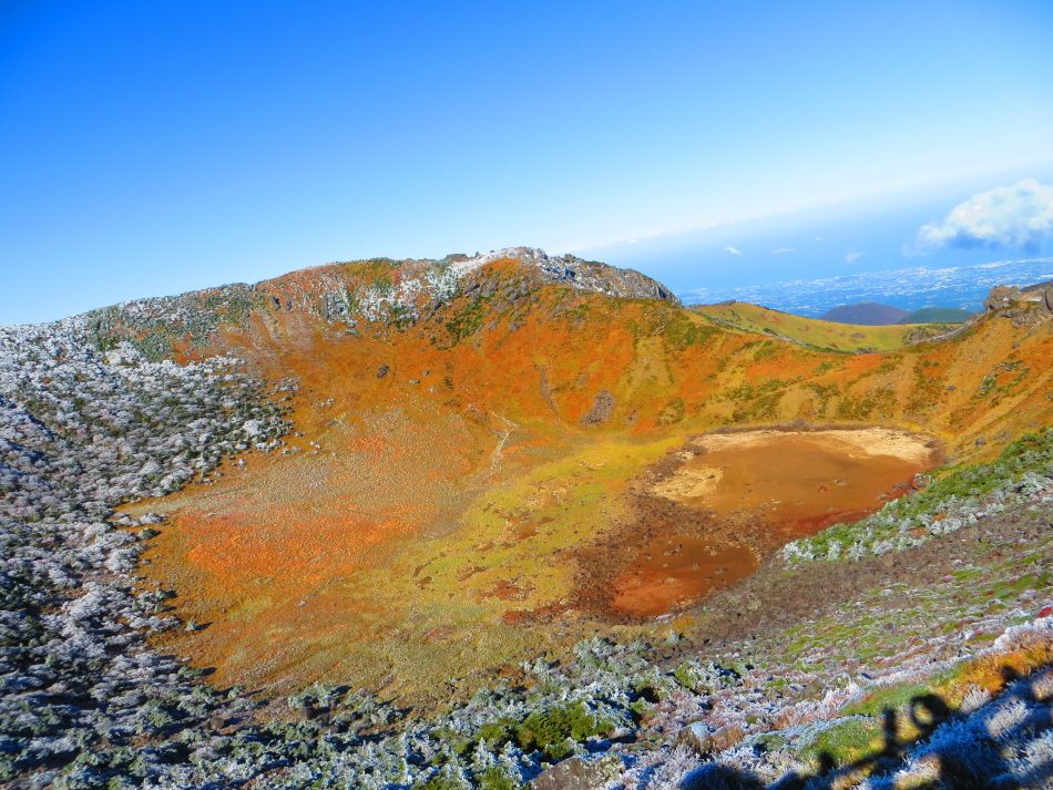 Baengnokdam Crater Lake at the summit of Hallasan Mountain
Standing 1,950 meters above sea level, Hallasan Mountain is the tallest mountain in Korea and one of four rare places in the world with the triple UNESCO designation of Biosphere Reserve, World Natural Heritage Site, and Global Geopark. This dormant volcano in the middle of Jeju Island is rightly known for its beautiful scenery, making it a popular destination for both islanders and visitors.
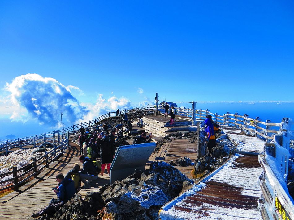 Snow-covered Hallasan Mountain
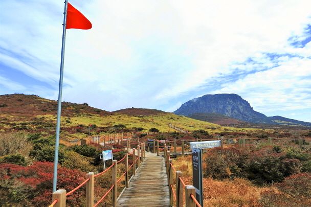
One of the charms of Hallasan Mountain is the variety of vegetation you will find as you climb the mountain. From the Tamnagyegok Valley to Baengnokdam Crater Lake, each step brings you to a new facet of Jeju’s nature. Note that the trail to the summit requires a reservation and has a limited capacity in order to protect nature.
-
 Sections of Hallasan Mountain’s Yeongil Trail
 -
 Sections of Hallasan Mountain’s Yeongil Trail
Jeju Island offers plenty of things to enjoy outside of hiking. From its natural sights to delicious food and quirky cafés, the island has so many things to experience. If you plan to hike Hallasan Mountain, make sure to leave enough time to see the island outside your hiking plans.
| Recommended Trails
• Baengnokdam Trail
- Length: 18.5 km
- Time taken: 10 hr
- Course: Seongpanak Parasitic Cone → Jindallaebat Shelter → Baengnokdam Crater Lake → Samgakbong Shelter → Tamnagyegok Valley → Gwaneumsa Temple
- Starting point: 1865 516-ro, Jocheon-eup, Jeju-si, Jeju-do (제주특별자치도 제주시 516로 1865)
- How to get there:
- - Take Bus No. 181 from Jeju International Airport Gate 2 → Get off at Seongpanak Bus Stop
- - Take Bus No. 281 from Jeju Bus Terminal → Get off at Seongpanak Bus Stop
- Tips! Hiking along the Seongpanak Trail brings you to the Saraoreum Fork. From here, you can proceed along a side trail for about 600 meters to Saraoreum Parasitic Cone, one of the mystical craters of Hallasan Mountain. Climbing the Saraoreum Parasitic Cone offers a great view of Baengnokdam Crater Lake, the rocks of Yeongsil, and the wide Seonjakjiwat Plain. If you can manage the hike, make sure to visit and see the view.
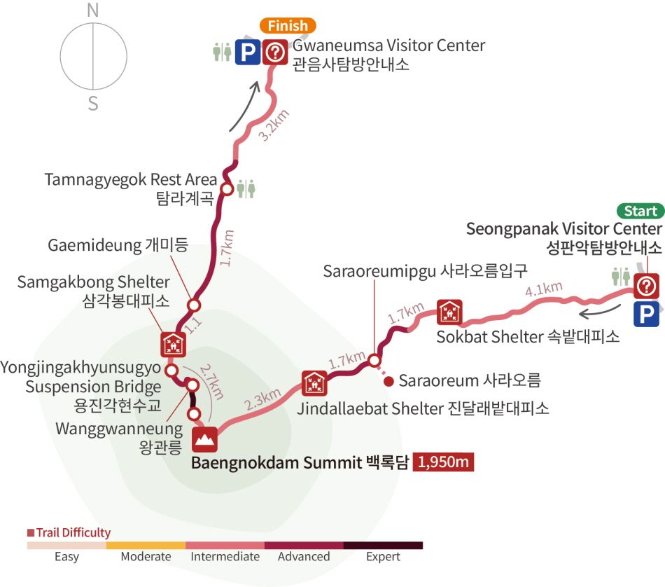
Hiking the National Parks of Korea
Seongpanak Trail, the most famous trail to Hallasan Mountain’s peak, boasts diverse scenic views. Go past the Sokbat Shelter and Saraoreum Parasitic Cone to find the Jindallaebat Shelter, after which the steep stairs begin. Once you reach the summit, however, you are rewarded with a great view of the island. The hike down isn’t boring, thanks to exciting features like suspension bridges. From Tamnagyegok Valley, the trek becomes gentle, allowing for an easy descent. If you want to take in nature and seize the triumphant view at the summit, reserve your spot for Hallasan hiking.
• Yeongsil Trail
- Length: 8.4 km
- Time taken: 5 hr
- Course: Yeongsil → Byeongpungbawi Rock → Witseoreum Parasitic Cone → Eorimok
- Starting point: Yeongsil Service Area, 495 Yeongsil-ro, Seogwipo-si, Jeju-do (제주특별자치도 서귀포시 영실로 495 영실휴게소)
- How to get there: Take Bus No. 240 from Jeju Bus Terminal → Get off at Yeongsil Ticket Booth Bus Stop
- Tips! The 2.5 kilometer-long road from Yeongsil Ticket Booth to Yeongsil Trail entrance, Yeongsil Rest Area, and parking lot is accessible only to vehicles with 12 seats or fewer. There is no parking space for personal cars due to crowding. If you are taking the bus, you have to walk the 2.5 kilometers until you reach the entrance to the trail. The most convenient way is to take a taxi to the entrance. After the hike, you can take a taxi back to your accommodation from the entrance to Eorimok Trail.
- If you choose to start from Witseoreum Parasitic Cone and proceed to the Nambyeok Observatory before returning to Witseoreum Parasitic Cone, it adds about 4.2 kilometers more of hiking to your trail.
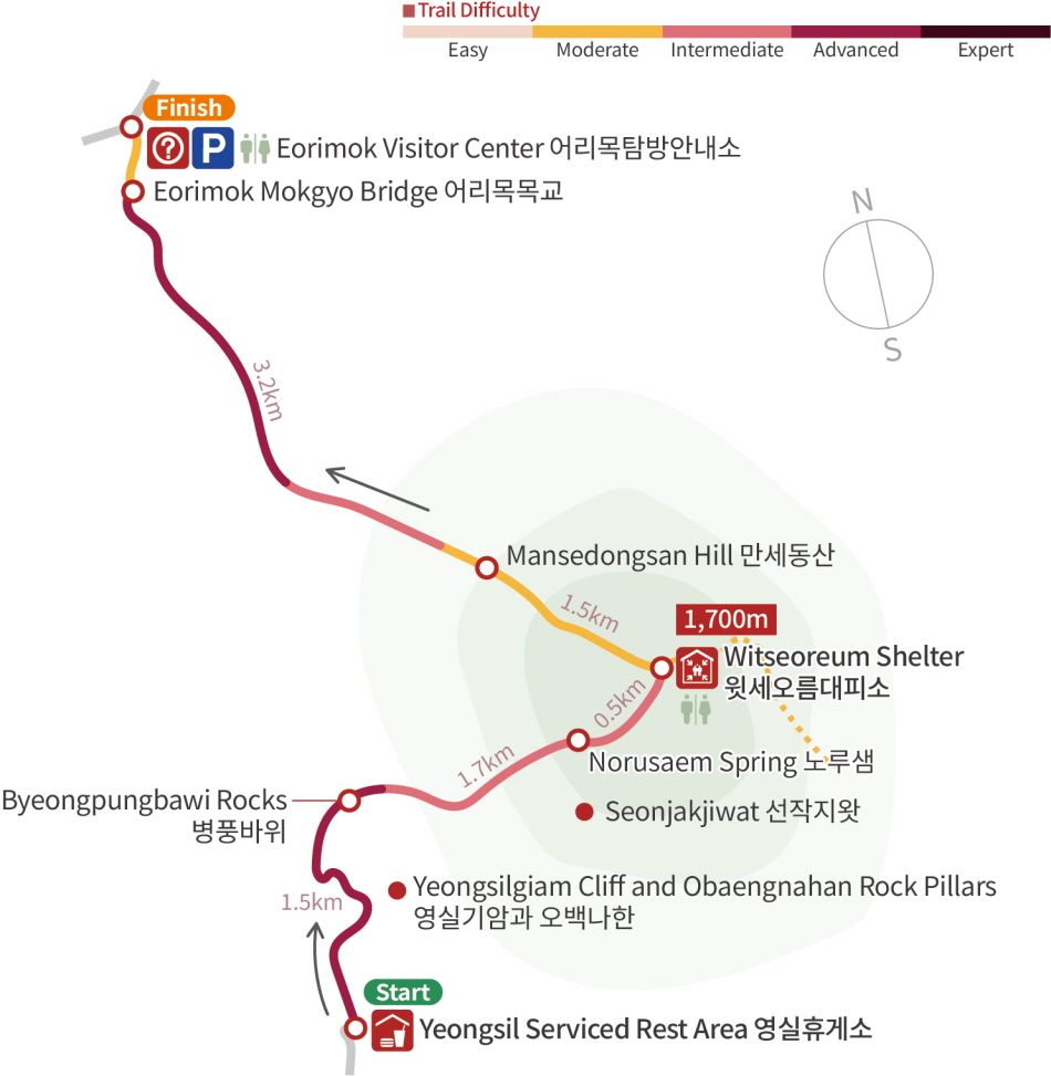
Hiking the National Parks of Korea
Yeongsil Trail is a charming trail where you can experience different facets of nature through flat roads and steep stairs. The road from Byeongpungbawi Rock to Witseoreum Shelter is quite steep and difficult, but the view at the summit is worth the journey. The road down to Eorimok Visitor Center allows you to enjoy lush forests and cool valleys embodying nature’s variety and beauty.
| Nearby Attraction
 Oneunjeong Gimbap
A roll of gimbap at the summit is an unmissable pleasure for Korean hikers. In particular, Oneunjeong Gimbap, one of the most famous gimbap shops in Seogwipo, Jeju-do, is constantly visited by hikers. The original Oneunjeong gimbap is filled with deep-fried bean curd, and you can also choose other menus like cheese gimbap and grilled galbi patties gimbap. Note that reservations are essential. If you are planning to enjoy your gimbap on the summit, make sure to visit the shop the day before and set up a pickup time.
Your Perfect Guide to Hiking in Korea: Hiking the National Parks of Korea
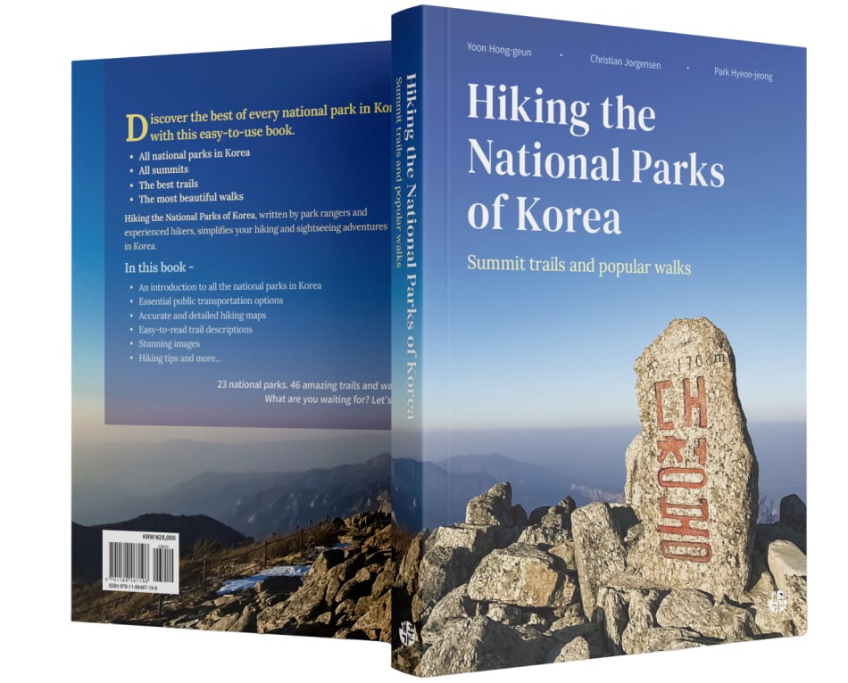
This guide is a comprehensive guidebook of 46 hiking trails you can cover in a day within 23 national parks in Korea. It was written jointly by two staff members of the Korea National Park Service (Yoon Hong-geun and Park Hyeon-jeong) and Christian Jorgensen, who collected the opinions of experts and seasoned hikers and visited the trails to choose only the best of the best. The book provides a thorough list of unique features and information essential to each trail and is lavishly illustrated with photos to bring it to life. Pick up this guidebook and delve into Korea’s beautiful world of national parks this fall.
*Most of this editorial’s content and photos (including infographics) were provided by the authors of Hiking the National Parks of Korea.
- 1330 Korea Travel Helpline: +82-2-1330
- 1330 Text Chat: https://m.site.naver.com/1rEid
- (Korean, English, Japanese, Chinese, Russian, Vietnamese, Thai, Indonesian)
*This column was last updated in September 2024, and therefore information may differ from what is presented here. We advise you to check details before visiting.
-


Xin vui lòng đăng nhập trước!